
ALACHUA – In a one-two punch, residents still reeling from the impacts of deadly Hurricane Helene braced for the anticipated devastating impact of Hurricane Milton.
Forecasted to strike land as a Category 3 hurricane, early in the week Milton intensified in the Gulf of Mexico, threatening coastal regions from Sarasota to the Big Bend area with severe winds, heavy rainfall, and storm surges. Officials predicted that Milton would make landfall in the Tampa Bay area.
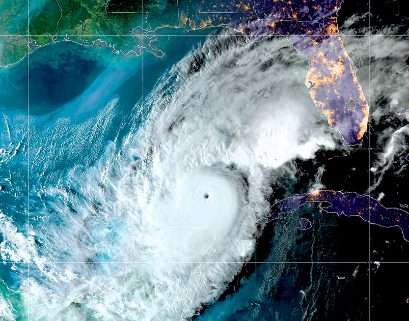
On Tuesday, Florida Governor Ron DeSantis issued a statement that as of 11 a.m. eastern time, Hurricane Milton was located about 520 miles southwest of Tampa, with maximum sustained winds of 150 mph. Milton will move across the eastern Gulf of Mexico and approach the west coast of Florida through Wednesday. The center is likely to make landfall along the west coast of Florida on Wednesday night and move east northeastward across central Florida through Thursday.
DeSantis expanded the state of emergency to 61 counties, urging evacuations in coastal areas most vulnerable to storm surges, such as the Big Bend and Panhandle regions. Watches and warnings are in effect along the Gulf Coast, as the National Hurricane Center continues to monitor the storm’s northward movement over the Gulf.
Evacuations from coastal areas began on Monda, Oct. 7, 2024. Tolls were suspended on facilities in West Florida and Central Florida as well as Alligator Alley and 595 Express to help facilitate traffic flow as Floridians evacuate.
The Florida Department of Transportation (FDOT) and the Florida Highway Patrol implemented Emergency Shoulder Use (ESU) on eastbound I-4 from Tampa to S.R. 417 in Central Florida and on Northbound I-75 in Tampa from North of I-4 to south of I-10 in Columbia County. This operation allows motorists to use the left shoulder as an extra lane in designated areas as well as keeps travel available in both directions, which helps to get people out and get supplies and resources in. Thousands of evacuees heeding official warnings have passed through Alachua County, both along I-75 and U.S. Highway 441 fleeing the impending catastrophic storm.
Residents should be mindful that after Hurricane Milton passes through, the immediate aftermath can be both dangerous and overwhelming.
Residents should wait for official announcements from local authorities that it is safe to venture outside. Hazardous conditions, such as fallen trees, live power lines, and flooding, can still pose significant dangers.
Flooded streets or yards may seem navigable, but even shallow waters can be dangerous. Water may be contaminated with chemicals, sewage, or hidden debris. Additionally, floodwaters can conceal electrical hazards from downed power lines.
Before re-entering your home, check for visible damage such as structural instability, gas leaks, or electrical hazards. If you smell gas or suspect a leak, leave immediately and contact emergency services. Avoid using candles or any open flames until you are sure there are no gas leaks.
If you are using a generator, be sure to operate it outdoors and away from windows to avoid carbon monoxide poisoning. Never connect a generator directly to your home’s wiring unless a licensed electrician has installed a transfer switch.
Wear protective gear such as gloves, boots, and masks while cleaning up debris. Sharp objects, nails, and hazardous materials may be hidden under rubble. Seek assistance from professionals for significant structural damage. For major repairs, hire only licensed contractors to ensure safety and compliance with local building codes. Be cautious of scammers who often appear after natural disasters offering low-cost repairs.
While the focus is on recovery, it's important to remember that hurricane season is still be ongoing. Once it's safe, begin restocking emergency supplies and updating your hurricane plan. Preparing early can make a significant difference in future storms.
# # #
Email editor@
alachuatoday.com
Residents Reeling from Hurricane Helene Braced for Milton
Tools
Typography
- Font Size
- Default
- Reading Mode